Map of the Festival & Directions
The Festival is held in the South Norwood Recreation Ground, next to Norwood Junction Train and Overground station.
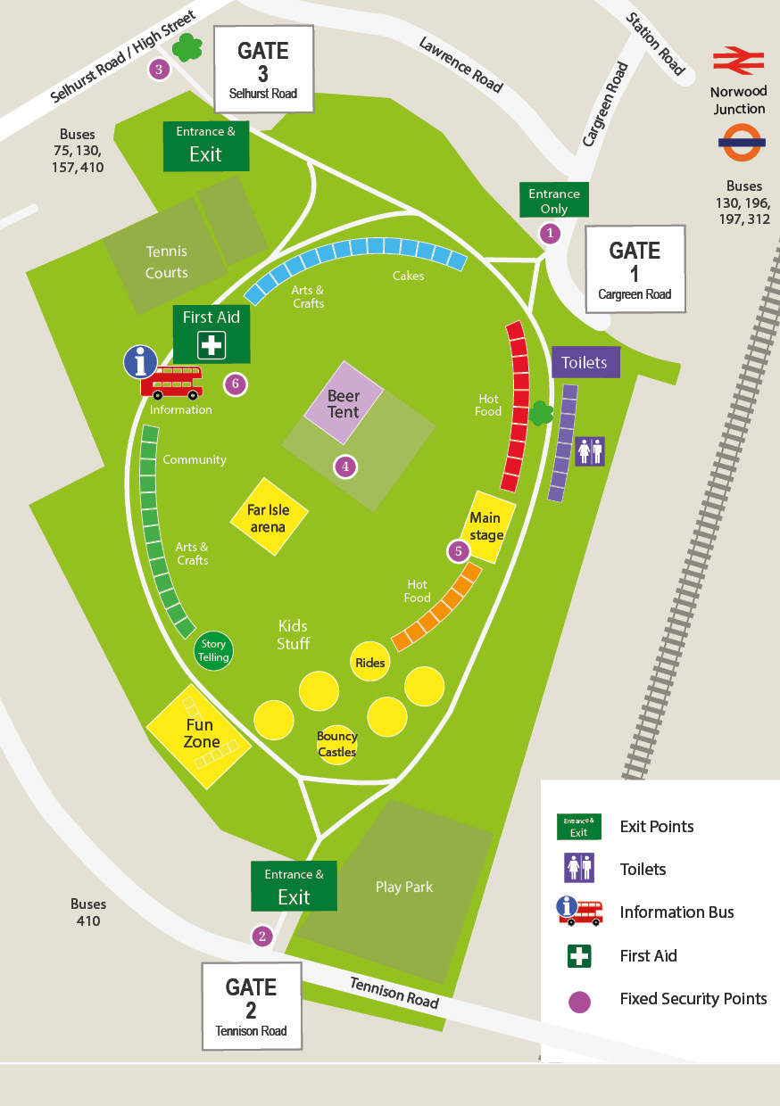
The park is 14 acres and has three entrances; the main entrance is on Cargreen Road, just 3 minutes from Norwood Junction Train Station.
Connecting Train Stations:
East & West Croydon, Anerley, Penge West, Crystal Palace, West Norwood, Tulse Hill, London Bridge, Victoria plus many more.
Connecting Overground Stations:
West Croydon, Anerley, Penge West, Sydenham, New Cross Gate, Surrey Quays, Canada Water.
Connecting Bus Routes:
196 (Bus Stop E) from Beulah Hill, Crown Point, West Norwood, Tulse Hill, Brockwell Park, Herne Hill, Brixton ...
75 (Bus Stop A) from Fairfield Halls Croydon, Selhurst, Anerley, Penge, Catford, Lewisham.
197 (Bus Stop P) from Woodside Green, Lower Addiscombe Road, East Croydon Station, and Anerley, Penge, Sydenham, Forest Hill, Dulwich, Peckham Rye.
312 (Bus Stop S) - South Croydon, Addiscombe, Woodside, South Norwood
130 (Bus Stop A or W) - from Thornton Heath, Woodside, Addiscombe, Shirley, New Addington
157 (Bus Stop A or W) - Morden, Carshalton, Wallington, Waddon, West Croydon, Selhurst, Anerley, Crystal Palace
410 (Bus Stop A or W) - Crystal Palace, East Croydon
468 (Bus Stop N is 5-10 minutes walk) buses from Beulah Spa, Crown Point, West Norwood, Tulse Hill, Camberwell, Elephant & Castle, and Fairfield Halls, Croydon Library, Swan & Sugar Loaf.
Please Note: Dogs, Alcohol and Glass Bottles are NOT permitted inside the main park. We have a licensed beer tent and area. Further information is available on our FAQ's page.
